Sunday, February 25, 2018

Kiven kivi? Looking for the rock that inspired Aleksis Kivi


Kiven kivi? Today's trip to look for cave underneath the large boulder in Nurmijärvi that may have inspired Aleksis Kivi in the writing of a the first significant Finnish language novel, "Seitsemän veljestä" (seven brothers). And there was a nice, 10m meter cave under the rock.

What a wonderful cave, not long, but perfect triangle, bright colours, smooth surfaces, and flat dirt floor... as Tuomo Kesäläinen writes in the book Uudenmaan Luolat: "a textbook example of a beautiful boulder cave".

This is an excellent cave to take kids and non-cavers to, btw. Easy to go through, dry, safe to approach, not much walking required, no fall danger (unless one climbs to the top of the stone), barely requires crawling, ... all good. Much recommended trip with kids.

I also mapped out the cave underneath. Here's the map:


A high-res version of the map can be also found in JPG and PDF formats. And the original iDraw file is here.

The coordinates are N 60.478192 E 24.760996, in Nurmijärvi. There's a designated parking spot at the beginning of the Kullantöyrääntie (honey's embankment road!).

I continued to after this to visit to my mom's place... and then somewhere for a sauna and a swim. More on the latter here.

Video:

Here's the view from the top:


More photos from under the rock:


The place is well documented and marked. There's even a parking spot next to the site on the road.


This article is also available at TGR. Tämä blogi löytyy myös suomeksi Relaasta. And many more caving articles are available at planetcaver.net. Photos, maps, and videos (c) 2018 by Jari Arkko. All rights reserved. The song "To the Top" is by The Silent Partner, and is freely usable from the YouTube music library.

Saturday, February 24, 2018

Swim in the East: Itäkeskuksen Uimahalli


I visited the Itäkeskus swimming hall after many years of not being there. It is one of my favourite community swimming pools.

It was also one of the early ones to have a "spa" or "water park" like features.

But the main thing is that it is *underground*. It actually doubles as an emergency shelter. The underground, inside-the-rock setup gives you a very special feeling. The main 50-meter pool area is one huge cavern; and the round jacuzzi is in a dark dome cave, with some sparkly things in the dome to remind you of the night sky... very nice!


Photos (c) 2018 by Jari Arkko. All rights reserved.

Another visit to Kuusijärvi


1/ It is -15C
2/ I had a nice smoke sauna & dip to lake
3/ But my car... dead. Now waiting for the tow truck.

Also, the moment when you realise that the tow truck guy recognises you and your car...


Photos (c) 2018 by Jari Arkko. All rights reserved.

Tuesday, February 13, 2018

Will a bunker eventually turn into a cave?


I wonder what happens to human-made underground structures, when enough time passes by? Will they turn into caves. or cave-like environments, eventually?

We had an opportunity to explore a Soviet-occupation era bunker in Solbacka, Kirkkonummi on Sunday.  This bunker was abandoned (and destroyed) 62 years ago.

In 2018, we found plenty of long, thin straw stalactites dropping from the roof. And a number of thick, beautiful stalagmites growing from the rocks upwards. 

Interestingly, some of the stalagmites appeared as if they had been cut at some point in time. A visitor breaking things years or decades ago?

We stopped our exploration and exited the bunker, however, when we realised that there was also a bat hibernating in the tunnel deep inside the bunker.

Cave forms, bats? Quite interesting.

I wonder what a large underground parking garage would look like after 100 or 500 years of neglect... probably very much like a cave.

On the trip we had Velma, Heli, Tor and myself. An idea for this Kirkkonummi exploration came from sitting at a Finnish Caving Association's bar evening on Thursday. 

Kirkkonummi is near, and has many interesting exploration destinations, ranging from small to large (by Finnish standards) caves, and hundreds of bunkers and other structures left by the Soviet occupation of Porkkala after the 2nd world war.

Coordinates: N 60.145421 E 24.431264.


Here are some cave forms:


And entrance & exit photos:


On our wintery march towards the site:


This blog is also available on TGR. Tämä artikkeli löytyy myös suomeksi Relaasta. Photos and videos (c) 2018 by Jari Arkko (1st, 3rd, 6th, 7th picture), Tor Paulin (2nd, 4th, 5th, 8th), Heli Karppanen (10th), and Velma Aho (9th). The song "Turnpike" is by Silent Partners, and freely available from YouTube music library. 

Saturday, February 10, 2018

February Swim


I went for a swim in the Allas Sea Pool today, again. Except that now it is February, and it is -5 C outside.

But, the pool was warm. I bought a swim cap to protect my head, and managed to swim 500 m in the rather crowded pool. The crowd was not on the furthest away lane, however :-)

And it was amazing. You're in a warm pool, light torches blasting from under the water and lighting also the steam rising from the pool... and you see the purple Ferris wheel above you... and occasional glimpses of Helsinki's historic buildings through the fog... and now and then a ferry speeds past the pool. What a place!

I did not, however, dare to enter the cold sea-water pool. Brr.


Photos (c) 2018 by Jari Arkko. All rights reserved.

Croatia!


Europe... the continent of many countries. So many that it is difficult to ski all of them... but on Christmas break I was able to visit Croatia, and finally ski its nice ski areas. What a wonderful experience to ski on mountains towering above the Adriatic Sea, sunshine, powder...

The first ski area that I hit was Sljeme, just outside Zagreb. This ski area sits on the 1035 meter Medvenica mountain above Zagreb. A curvy, lonely road leads to the mountain. I started driving in what felt like a rainy, cloudy fall afternoon. By the time that I got to the top, I was in full-blown snowstorm, and worried about the ability of my car to navigate the snow that was piling on the road. But I finally found the ski area, and was able to park.

The only problem was that the ski area had just closed. Fortunately, they would open for evening skiing in two hours, so I sat down for a dinner at the restaurant at the top, and waited.

Once the ski area opened, it was great! Not big, and only 300 meters of vertical, but they have run World Cup races here. It also turned out that there had been a gondola that would have allowed me to bypass the gnarly road. However, it broke down in 2007 and is being replaced by a new one that is scheduled to open in 2018. One would hope... that's a long repair wait.

I also realised later that in this area there would have been an interesting cave, Veternica, a 2.6km cave with tours for tourists. I wish I had realised earlier that a visit in a cave was an option...

But I was already on my way to Platak, a ski area with a similar 263-meter vertical difference, but located in what felt a much more mountainous area, with the peak being at 1363 meters. And, most importantly, there's a view to the Adriatic Sea from the slopes! I really liked this ski area, and the recently fallen foot of fresh powder made it even nicer. Nobody seemed to have skied the forests and areas between slopes, so I had a lot of fun for myself.


Pictures from Sljeme are below. First, there's a link tower at the top of the mountain. In the snowstorm it looked wonderful:


Here's how the ski slopes looked:


Near the top of the ski hill there's a small bar hut. In the evening lights it looked very good:


I also ate at the restaurant at the top, while waiting for the ski lifts to open for the evening. This is a picture of the restaurant window:


Pictures from Platak are below:


This is the bar at the bottom of the main ski slope:


I stayed in a village, Furize, half an hour drive from Platak. The villa that I was staying at (Villa Moya) had an outstanding view, when the morning arrived:


This blog article is also available on TGR. Tämä blogi löytyy myös suomeksi Relaasta. Photos and videos (c) 2017 by Jari Arkko. All rights reserved. The song "Royal" is by Josh Lippi and The Overtimers, and is freely available from YouTube music library.

Friday, February 9, 2018

Sauna at the Grand Hotel Beau Rivage


Janne and I visited Interlaken, and stayed at the Grand Hotel Beau Rivage. A grand, old style hotel, and I of course also wanted to visit their pool & saunas department.

The pool was nice but basic. The two saunas (dry and steam) were in a separate area. The dry sauna was quite good. And once again there was a bit of figuring out what the local customs were. The signs indicated that the sauna areas were mixed & naked only, although on some days the customers seemed to use swimming pants. Whatever works, for people I guess. In any case, I was glad that I got to a sauna after cold and sometimes soaking wet days on the slopes.

Photos (c) 2018 by Jari Arkko. All rights reserved.

Swiss Chocolate Adventure


Uh... a museum... a ride... of chocolate. But we are in Switzerland, so it is all as expected.

This was in the Verkershaus, a museum of transport in Lucerne.


Photos (c) 2018 by Jari Arkko. All rights reserved.

Thursday, February 8, 2018

Skevabackgrotta: Search for the Lost Cave


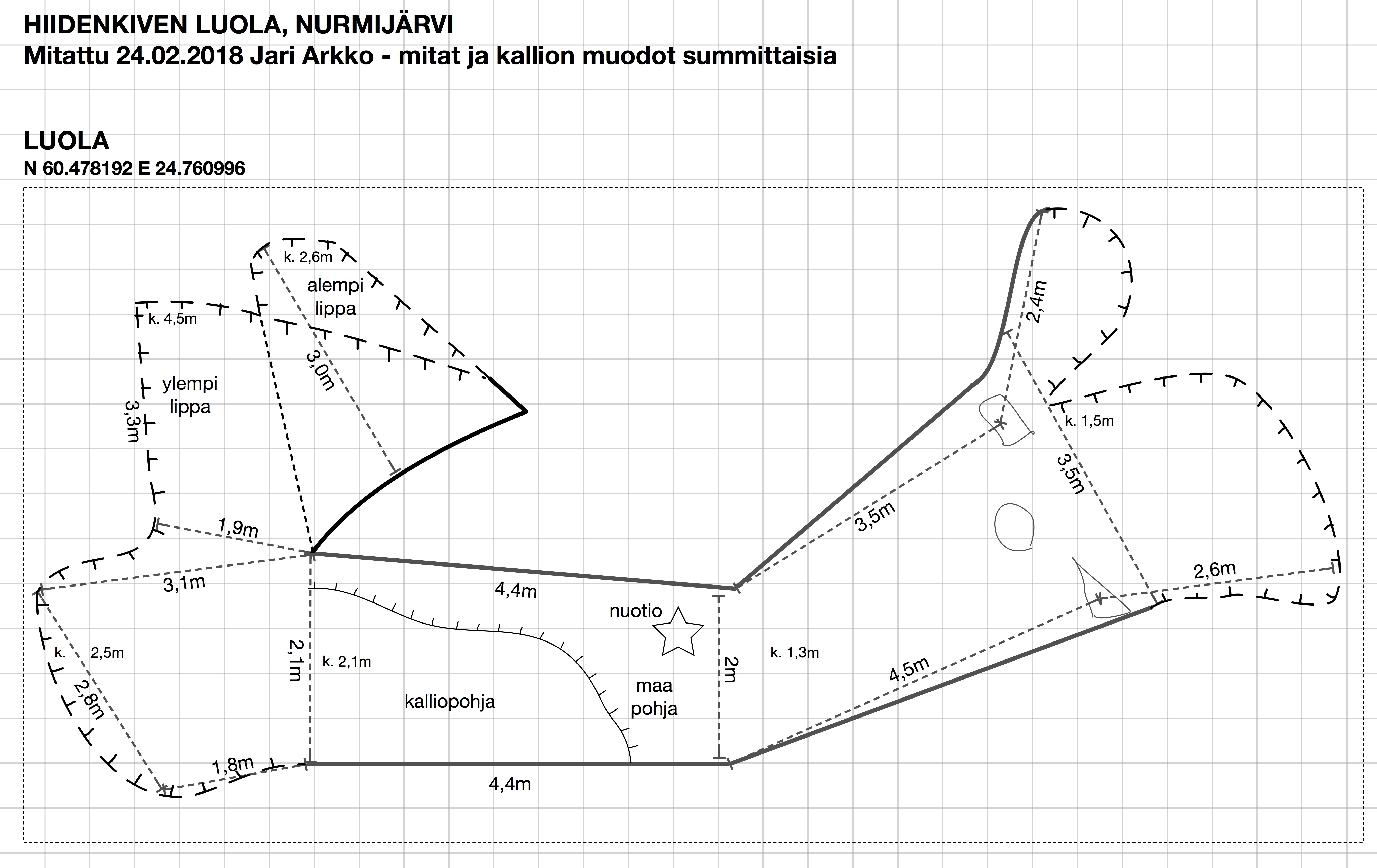
Jarmo and I have been looking for a lost cave. The Finnish Caves book notes a rumour of the "Skevabackgrotta" cave in Kirkkonummi, but does not give exact location. And notes that the cave entrance has collapsed:
"xxx 1. Skevabackgrotta, Kirkkonummi, 2032 08 Kirkkonummi, x=6666,xx, y=2526,yy. 2.4. Längstrandin maalla. Suuakko on romahtanut. EI TARK."
This is difficult to interpret, but the location points to somewhere north of the Peuramaa ski area. This is close to the Högberget cave. I've always had a suspicion that the Högberget cave might be a beach cave rather than ice age cave, now lifted 30 meters higher due to rising ground in the last 10 000 years. Could the Skevabackgrotta be a similar one?

So I figured I'd systematically search the nearby areas, as the indicated coordinates are only one km2. And given the theory about the beach cave, I decided to follow the same 25-30 meter height contour line in the forests. I didn't find much on my first search, but the next day Jarmo joined the search party.

The algorithm did seem to pay off. In the same height level there were actually many vertical and horizontal cracks, and some of them were equally worn as the Högberget cave.

We found one clear cave, a horizontal crack with two cave parts each able to hold one person. Ok, not much, a really small cave, perhaps not listed as a cave by anybody else than us. And this was also not the cave we were looking for, as it had not collapsed.

There was another horizontal cave in the middle of a larger cliff face. It was easily reachable still, but turned out to be small. Maybe, just maybe, when the ice and water clears in the summer it becomes big enough for a person to fit in.

We found a vertical crack that I could see well enough into, did it have a small cave at the top or not? I climbed a fallen tree to see better, but the rotten tree didn't really enable me to go sufficiently high. Still, we think there's no opening here.

But finally, we found a vertical crack that goes through a section of a cliff, with both ends accessible. The crack is small, and filled with stones. On one end there's a clear devil's churn, and the other end is also worn by some forces. On the devil's churn end, it is, however, possible to squeeze into the crack. At first, it didn't feel possible, but then I took a few layers of clothing off, and was able to make it in.

This part of the crack has a round boulder hanging high in the crack, and a few meters forward the crack becomes filled with lodged boulders and rocks. If those rocks were higher up some day, this would have been a small cave. Perhaps sometime in the past the whole crack was free, and one might have been able to go through the 5-10 meters?

Difficult to tell. Is this Skevabackgrottan? The best hint that it might be comes from Jarmo, who notes that we are standing on the Skevabacken cliff... maybe... and I'm pretty sure there's nothing else on this hill. Unless it has been completely levelled and destroyed. Who knows, but I think this is at least with some likelihood the right place. What the cave looked like 100 or 10000 years ago, we don't know.


Here are some more pictures and exact locations. The horizontal crack on the big cliff (coordinates N 60.10512231 E 24.47254300):


The small horizontal crack and a two part cave (coordinates N 60.10511529 E 24.47416900):


The vertical crack with a possible (unlikely) cave at the top (coordinates N 60.10528759 E 24.47533234):


The devil's churn cave (coordinates N 60.10566582 E 24.47646343):


At the very end of this cave:


Reducing clothing to fit in:


The other side of the devil's churn cave (coordinates N 60.10568456 E 24.47630875):


On the walk we also saw an odd boulder with stones next to it that are either natural, or were bing quarried somewhere:


This blog article is also available at TGR. Tämä blogi löytyy myös suomeksi Relaasta. Photos and videos (c) 2018 by Jari Arkko and Jarmo Ruuth. All rights reserved. The music is from YouTube music library, and free for use: Friday Morning by Kevin MacLeod is licensed under a Creative Commons Attribution license (creativecommons.org/licenses/by/4.0/) Source: incompetech.com/music/royalty-free/index.html?isrc=USUAN1100224 Artist: incompetech.com/